Fires, deforestation and road construction: satellite imagery shows what impacts the land use in Siberia and in the Far East
5 November 2020 г.

Siberia and the Far East occupy about a tenth of the land on the planet. This mineral-rich, mostly forested and frozen area is extremely important as a source of economic and environmental benefits. Despite the low population density, the influence of the human factor on Siberia and the Far East is noticeable. However, it is not easy to assess. Local problems may not be seen on a huge scale.
A simple indicator reflecting the area disturbance is the type of land use. The processing of satellite images makes it possible to classify the character of the land use, to identify settlements and roads, logging zones, burnt-out areas, and intact ecosystems. One of the advantages of satellite information is the time series of observations of our planet. This means that one can see not only how the land area is currently being used, but also compare the current situation with the past.
A team of scientists from the USA, Finland and Russia, including a researcher from the Krasnoyarsk Science Center SB RAS estimated through satellite imagery the changes associated with human use of the areas of Siberia and the Far East, which occurred from 1975 to 2010. The researchers identified several patterns common to different regions. The most obvious is the increase in the number of roads. Moreover, the growth was not due to large highways linking settlements or areas with dense population. The greatest growth in the network of secondary roads is observed in the forested regions of the Far East remote from housing. This is likely to be related to the construction of permanent or temporary roads to transport timber from logging sites, including illegal logging.
The scientists also compared the impact of fire and logging on a number of areas. Fires are the main factor which has significantly changed the appearance of forests over the years. However, for some districts, for example, the Tomsk region and the Krasnoyarsk Region, the areas which fell under tree cutting are comparable in area with those that were burnt out.
For the study, the scientists used space images obtained within the Landsat program. It is the longest running project of the satellite imagery of the Earth. The first of the satellites was launched back in 1972. Over the years, within the program, eight satellites have been sent into space, whose images are available for scientists all around the world for solving various problems.
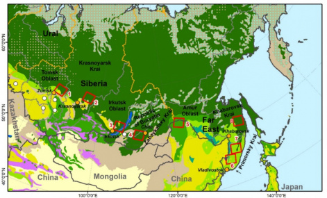
It is not an easy task to assess the changes which have occurred over 35 years on each square kilometer of a huge territory. In this study, scientists analyzed eight model sites located in the Tomsk, Irkutsk and Amur Regions, as well as Krasnoyarsk, Zabaikalsk, Khabarovsk and Primorsk Regions. The area of each site is just over 30,000 square kilometers. Of course, in total they occupy an insignificant area in comparison with the size of the territory. At the same time, these are demonstration areas located in the zone of active land development.
After the scientists collected satellite images of the selected sites for the entire time period, various processing algorithms were applied. Analysis of satellite information is a separate and laborious task. Scientists used several approaches, comparing images in different spectral ranges and using vector maps to achieve the most accurate classification of underlying surface types.
“In our analysis, we covered the period of intensive growth of the Soviet economy, collapse of the Soviet Union, depression of the 1990s and the subsequent economic rise of Russia. During the Soviet era, there were interrelated changes in the area of settlements, agricultural land and road network. In the 1990s and in the beginning of this century, these processes are loosely connected. The area of settlements hardly changes, agricultural land even decreases, while the temporary road network grows and enters remote areas, ” says one of the authors, Doctor of Biological Sciences, head of the forest monitoring laboratory at the V.N. Sukachev Institute of Forest KSC SB RAS, Professor of Siberian Federal University, Vyacheslav Kharuk.
In conclusion, the authors note that the results obtained can be considered as the basis for further research. Space images with a higher resolution, expansion of the time series of images and shooting frequency, as well as more complicated image processing algorithms can be used both to clarify many key issues and to increase the area coverage in Siberia and the Far East.
Share:
