Satellite data will help predict crop yields in the Krasnoyarsk Region
16 April 2020 г.

What is the early forecasting method for grain crops based on?
In fact, remote sensing data are a set of numbers. In the case of vegetation observations, these figures primarily characterize the quantity and quality of photosynthetic pigments. To use such data in practice, it is necessary to find a correspondence between the real state of the plant and the results of remote measurements.
There are many difficulties here, since even the same plant on different types of soil, in different weather or climatic conditions, can have a different optical reflection spectrum. The task of any digital farming technique is to compare the data of simultaneous ground and remote observations and develop reliable algorithms for deciphering space signals. Roughly speaking, we must do dozens of examinations of plants in different conditions on the earth and find some relation between their state and the spectral signal. In the future, there is hope that the decryption of the signal occurs with high accuracy, that is, we will know the condition of the plant only by its spectral pattern. And then we can use remote data.
Of course, the reality is still more complicated. So, in addition to optical spectral signals from plants, we can remotely receive data on soil temperature and humidity, and height of the measured surfaces. Ultimately, to predict yield, we need to find some relationship between the results of various observations. It is important to understand that algorithms designed for one locality may not work well in another region. In our case, it is necessary to take into account the features of Siberia.
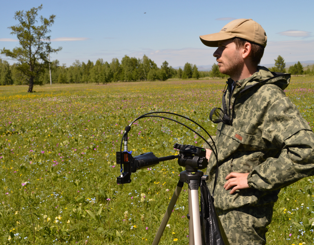
In this project we are planning to use an integrated approach, to attract all sources of spectral information, namely the data obtained from satellites, unmanned aerial vehicles and ground-based spectrometry. It is important for us that the method should be efficient for large areas, while providing accurate information for small areas as well. Ground experiments will be carried out together with our colleagues from the Krasnoyarsk State Agrarian University at a test site which is typical of the agricultural part of the Krasnoyarsk Region. The types of crops in this area, the specific character of their growth during the summer season will be described.
For mapping yields, use will be made of a three-level system for optical monitoring of agricultural lands. The reasons for this are extremely simple. For satellites, the equipment allows us to measure large areas, but has a relatively low spatial resolution. Therefore, such measurements are not enough to control small areas of the experimental field.
The situation with the ground measurements is just the opposite. Such measurements are characterized by high accuracy and location referencing, but they cannot be used for large areas. Here, an obvious conclusion suggests itself – it is necessary to use unmanned aerial vehicles flying at a low altitude, which are equipped with spectral devices. This technology of remote sensing almost compensates for the shortcomings both of satellite and ground monitoring.
Ideally, precision farming technologies should employ all three types of optical remote sensing. For large agricultural areas, the rational use of satellite equipment is appropriate. Ground-based spectral equipment is needed to improve technology and verify measurements. For small agricultural facilities and detailed monitoring, low-altitude drones are ideal.
What are the advantages of using such a technique in agriculture?
It is important to predict crop yields for food security and management decision-making in agriculture sector. So, in years of adverse weather conditions, the yield forecast allows one to reduce damage, and in favorable years to determine the possible volume of grain exports and markets.
Moreover, if we learn to build crop yield forecast maps, it will become possible to purposefully find areas with low productivity, study the causes of this decline at this site of the field and take appropriate measures to solve the problem. For example, such maps can be the basis for differential fertilizer application in precision farming.
When submitting an application, you probably took into account the groundwork already done for the implementation of the project. What are the most striking and/or interesting results obtained to date in this field of research?
The development program of the Federal Research Center “Krasnoyarsk Science Center SB RAS” allowed us to purchase modern equipment for accurately calibrating satellite data. These are modern unmanned aerial vehicles (drones) equipped with instruments for measuring spectral characteristics of vegetation. Over the last few years, we have obtained a number of interesting results, allow us to speak about technologies to be soon implemented in agriculture.
As mentioned above, the development of an algorithm for the crop yield prediction is divided into many small subtasks. For example, during the last years for test sites where the research will be conducted, we identified the heterogeneity of the soil cover in the area and showed a possibility of its diagnosing based on remote sensing data. We developed and verified a method for remote determination of vegetation boundaries using satellite data. We found a relationship between the total number of photosynthetic pigments in wheat, barley, oats and the crop yield under various cultivation conditions. We developed a method for estimating the yield of spring barley, which is based on the use of optical ground and satellite spectral data.
What are you anticipating to achieve in particular, as a result of the project? What new knowledge will be gained or what are methods to be developed?
In principle, the main goal of the project is formulated in its title. We are planning to develop a comprehensive system for early prediction of grain yields based on remote sensing data using ground-based, unmanned aerial and satellite spectrometry, taking into account ground-based field information on the state of crops. The results obtained are an integral part of the development of the "precision farming" approach. As to the particular objectives, we are to develop methods and build maps of grain yields using satellite, unmanned aerial and ground-based data with a spatial resolution of at least 3 meters. In addition, a method for differential fertilizer application based on the crop state maps will be developed.
When can we expect such a technique to be put to practice?
The developed technology for early predicting grain yields will be tested on the fields of the educational and experimental farm "Minderlinskoye" during the implementation of the project itself. In the same test fields, we are going to perform differential fertilizer application. Further, the plan implies a gradual increase in the area of the controlled lands to test and improve the quality of forecasts. In the future, the whole region is to be covered by new technologies.
In addition to productivity, digital technologies can be applied at all stages of growing plants in the fields - from monitoring the state of crops to improving fertilizer application technologies, and suppressing weeds and pests. All this is a practical implementation of modern digital farming.
Share: